


A professional hydrographic surveying firm operating in the Port of Rotterdam, Europe's busiest maritime hub, faced a critical equipment upgrade decision. Their legacy differential GPS systems, while serviceable, required expensive base station infrastructure and delivered only sub-meter accuracy, insufficient for modern dredging monitoring and seabed infrastructure mapping requirements.
The firm turned to Jumpstar's RTK-GNSS OEM boards to modernize their survey vessel positioning systems. The transition not only improved positioning accuracy by an order of magnitude but also reduced total equipment and operational costs by 40%, fundamentally changing their competitive position in the marine surveying market.
Maritime Positioning Challenges
Hydrographic surveying presents unique GNSS challenges distinct from terrestrial applications. Multipath reflections from water surfaces, dynamic vessel motion, and the need for continuous RTK coverage across large port areas demand robust receiver performance under conditions that stress conventional systems.
- Water Multipath: Flat water surfaces reflect satellite signals with near-perfect coherence, creating persistent multipath that biases position solutions by meters if unmitigated.
- Vessel Dynamics: Roll, pitch, and heave motions during survey operations require high-update-rate position and attitude data synchronized with sonar measurements.
- Port Infrastructure: Large container cranes and vessel superstructures intermittently block satellite visibility, requiring rapid reacquisition and multi-constellation redundancy.
- Cost Pressure: Legacy DGPS subscription fees and dedicated base station maintenance consumed a significant portion of annual operating budgets.
Accuracy is our product. When clients hire us to map a dredging channel or survey a pipeline route, they expect survey-grade precision. Jumpstar's OEM boards deliver that precision at a price point that lets us remain competitive on international tenders.
Deployment and Operational Results
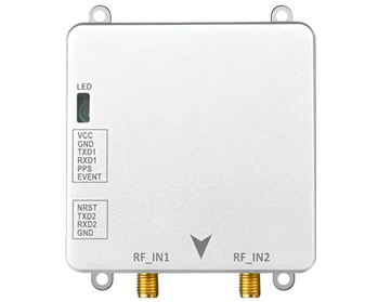
Jumpstar OEM boards were integrated into the firm's three survey vessels, replacing legacy single-frequency DGPS receivers. Each vessel now receives RTK corrections via the national NTRIP network, eliminating the need for proprietary base stations. The boards' low latency and 20Hz update rate synchronize seamlessly with multibeam sonar systems.
Operational benchmarks confirmed horizontal accuracy of 1cm + 1ppm and vertical accuracy of 2cm + 1ppm, exceeding International Hydrographic Organization (IHO) Special Order requirements. The firm has since expanded its service offering to include autonomous underwater vehicle (AUV) tracking, leveraging the same RTK infrastructure for surface positioning.

.png)


