




P2A
.jpg?imageMogr2/format/webp)
.jpg?imageMogr2/format/webp)
.jpg?imageMogr2/format/webp)
.jpg?imageMogr2/format/webp)
.jpg?imageMogr2/format/webp)
.jpg?imageMogr2/format/webp)
P2A
Surveying RTK Rovers
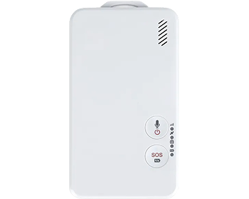
Jumpstar P2A Bluetooth Handheld Positioning Device – Compact GNSS Personnel Tracking Terminal with SOS Alarm
Bluetooth 4.0 Positioning Output
Transmit NMEA 0183 data to Bluetooth receivers in real time.
Multi-Constellation GNSS Tracking
Supports GPS, GLONASS, SBAS, QZSS for stable positioning.
Personnel Management Full-Featured
Track query, electronic fence, blind zone data retransmission.
One-Key SOS Alarm
Emergency help alarm with indicator prompt for outdoor safety.
Long Endurance
2500mAh built-in battery, up to 8 hours working time.
Compact & Portable
130×55×38mm, 104g lightweight handheld design.
Flexible Configuration
SMS/platform remote parameter setup & remote firmware upgrade.
Wide Compatibility
DC 5V power supply, Type-C charging for easy daily use.
Jumpstar P2A
Bluetooth Handheld Positioning Device
The P2A is a new-generation Bluetooth BDS handheld positioning terminal independently developed by Jumpstar. It adopts a compact and lightweight structure with a professional positioning chip, featuring strong anti-interference and stable positioning performance.
Connected with a satellite positioning management platform, it realizes personnel positioning, scheduling, trajectory analysis, data collection and other management functions. It supports Bluetooth 4.0 data output, SOS emergency alarm, electronic fence and blind zone data retransmission, widely used in railroad inspection, fire emergency rescue, forestry patrol, outdoor operation and other personnel positioning scenarios.
Bluetooth 4.0 output, multi-constellation GNSS, SOS alarm, long endurance, and compact design make P2A an ideal personnel tracking terminal.
.jpg?imageMogr2/format/webp)
Key Features & Benefits
-
Multi-Constellation High-Stability Positioning Supports GPS L1 C/A, GLONASS L1OF, SBAS L1 C/A, QZSS L1 C/A; positioning accuracy 2.5m CEP.
-
Bluetooth 4.0 Data Transmission Outputs positioning data in NMEA 0183 format to Bluetooth receiving devices in real time.
-
Comprehensive Personnel Management Supports location query, track query & playback, parameter query, version query and electronic fence (up to 50 groups).
-
Emergency SOS Alarm Function One-key help alarm; uploads alarm information immediately and lights up indicator for status prompt.
-
Blind Zone Data Supplementary Transmission Automatically stores position data in signal blind zones and uploads automatically when signal recovers.
-
Long Endurance & Convenient Charging 2500mAh built-in battery; 8 hours working time; Type-C charging interface, DC 5V power supply.
-
Remote Operation & Maintenance Supports SMS/platform remote parameter configuration, remote reboot and remote software upgrade.
.jpg?imageMogr2/format/webp)
Technical Specifications
GNSS Performance
| Product Type | Bluetooth Handheld Positioning Device |
| Supported GNSS Signals | GPS L1 C/A, GLONASS L1OF, SBAS L1 C/A, QZSS L1 C/A |
| Positioning Accuracy | 2.5m CEP |
| Positioning Reporting Interval | 1 second (default) |
| Bluetooth Version | Bluetooth 4.0 |
Electrical & Mechanical
| Working Voltage | DC 5V |
| Peak Current | 3A |
| Built-in Battery | 2500mAh |
| Working Time | Up to 8 hours |
| Charging Interface | Type-C |
| Dimensions | 130mm×55mm×38mm |
| Weight | 104g |
| Operating Temperature | -20℃~+70℃ |
| Operating Humidity | 20%~95% non-condensing |
| LED Indicators | GPS (Green), BT (Blue), Power (Red) |
| Main Functions | Position query, track playback, electronic fence, SOS alarm, blind zone retransmission, remote upgrade |
Typical Applications
Railroad Inspection & Maintenance Personnel Positioning
Real-time tracking for railway workers to ensure safety and efficiency
Fire Emergency Rescue & Disaster Relief Personnel Tracking
Real-time location and SOS alarm for firefighters and rescue teams
Forestry Patrol & Outdoor Law Enforcement Management
Track patrol routes, enforce boundaries, and ensure officer safety
Outdoor Operation & Field Construction Personnel Monitoring
Monitor workers in remote construction sites and outdoor projects
Event Personnel & Team Activity Positioning
Track staff and participants during large events and outdoor activities
Outdoor Data Collection & Mobile Patrol
GPS-enabled data logging and patrol route verification for field workers
Resources & Downloads
P2A Datasheet
Complete specifications, pinout, electrical and mechanical details.
Mechanical Drawing
2D/3D mechanical dimensions and product layout (130×55×38mm).
User Manual
Quick start guide, integration tips, and configuration protocols.
3D CAD Model
STEP, IGES and STL formats for mechanical integration (130×55×38mm).
Frequently Bought Together
.jpg?imageMogr2/format/webp)
X43H-AH
Jumpstar X43H-AH Multi-Constellation Multi-Frequency RTK Receiver – 789 Channels, Dual-Antenna Heading, Ultra-Compact High-Precision Positioning Module
.jpg?imageMogr2/format/webp)
P-Box-X10
Jumpstar P-Box-X10 Multi-Constellation Triple-Frequency GNSS Receiver – 544 Channels, 100Hz Update, Dual-Antenna Heading & RTK High-Precision Module
.jpg?imageMogr2/format/webp)
P-Box-X6 S
Jumpstar P-Box-X6 S Multi-Constellation Multi-Band GNSS Receiver – 448 Channels, 100Hz Update, RTK Centimeter-Level Positioning & Heading Module